John Norden - Revealing the Face of Tudor Cornwall
Last month I introduced readers to John Leland the first of three 16th century antiquarians from England who had contributed much to our knowledge about Cornwall’s history during that period. We will meet John Leland again in the coming months, but today we look at part of the work relating to Cornwall of the second of these men, the surveyor and cartographer John Norden.
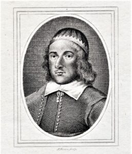
Sadly, not as much is known about John Norden as we would perhaps wish, and his work was not fully appreciated until much later after his death in 1625. During a period where cartographers and topographers relied on a degree of patronage to enable publication of their work, lack of ongoing patronage, through death of patrons, meant that some of Norden’s work remained unpublished until after his death.
Norden tells us he was born in Somerset about 1547, although believed to have been the son of a mere yeoman he attended Oxford University until the age of 25 and afterwards was known to have been writing religious works, the first of which sold extremely well. Service with landed gentry led to him becoming a surveyor and then a cartographer, hence the production of his maps of Cornwall and elsewhere.
Unpublished during his lifetime, Norden’s maps of Cornwall were until 1970 only known by their inclusion in the publication of ‘Speculi Britanniae Pars. A Topographical & Historical description of Cornwall’, by Christopher Bateman in 1728. Those maps were originally thought to have been missing and substituted by Bateman for others to support Norden’s text. Recently these have been proved to have actually been Norden’s original maps thought lost. The story of the lost manuscript and maps is tortuously long and not applicable for this article.
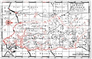
Norden split his work into the various Cornish Hundreds as well as commencing with a general history of Cornwall and is thought that his survey took place from about 1597. During his travels around Cornwall he passed his opinions on many Cornish towns, or as he describes them from his time and viewpoint hamlets. Looking this week at the Easte Hundred of Cornwall, the map shows a glaring mistake made by Norden in that where he labels it, part of Powder Hundred, this area is in fact Easte Hundred.
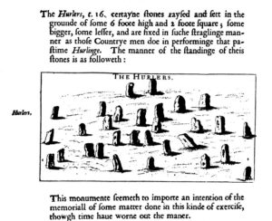
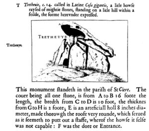
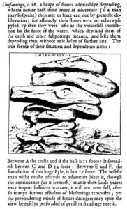
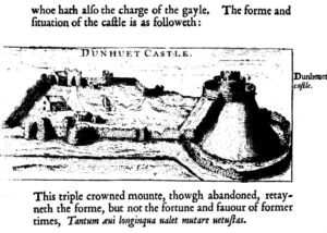
In his ‘Speculi Britanniae’ for Cornwall he also observes and comments on thirteen of the most remarkable curiosities within Cornwall. Within Easte Hundred these include the Cheesewring, Launceston (Dunheved) Castle, and the Hurlers stone circles.
His description of these three is included here, along with his drawing, so readers can see what he had to say about them in his own words of the time.
No early topographical journey into Cornwall could have taken place without mention of Launceston due to the positioning of historic bridges crossing the Tamar, many still in use. In modern English, Norden describes Launceston as a pretty town, neatly kept and well governed by a Mayor and his brethren. He says that during festivals they wear scarlet robes and that the affairs of the whole province take place in the Castle of Dunhevet adjoining the town. Norden confirms that Launceston was a borough and that in the 32nd year of Henry VIII’s reign, 1546-1547, an act was passed for the repairing of Launceston amongst other decayed Cornish towns. However, he comments that although the statute took little effect the town had improved its buildings and increased in wealth during recent years.
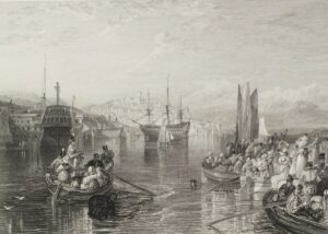
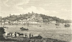
Saltash is mentioned and seen as benefiting from its navigable access to the sea. Also described as a pretty market town that was governed by a Mayor and ten assistants. It had sundry ‘large privileges’ and sent a burgess to parliament. Saltash benefited by taxing boats and barges that used the harbour as well as for anchorage from all ‘stranger’ ships. Norden comments that Saltash benefited from passage between it and Devon and increased daily in merchandise and wealth. The town owned eight ships as well as smaller boats and that the haven is capable of any size vessel. This included the great ‘Carrack’ that Sir Francis Drake brought home containing great riches. This great vessel described as a carrack was unloaded, but afterwards somehow caught fire and sunk.
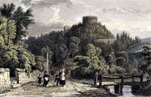
The engravings here are from about 200 years after Norden's time, when he wrote about them. Hopefully they provide some idea of the places he talked about.
The other place of any major note within this hundred mentioned by Norden is Trematon Castle. This unlike the towns of Launceston and Saltash is a sadder story. Trematon a place where formerly the Earls of Cornwall and other governors of Cornwall lived, belonged to the Duchy. He comments further that want of ‘Princely preference’ has led it to fall daily into ruin and decay. The inner buildings have collapsed with only ragged walls remaining. Some lodgings within the bailey remain along with the prison. There is a steward, a bailiff and a porter although these are not required.
Interesting to see how various places within Cornwall fared, between the Domesday Book of William I in 1086, to somewhere about halfway in the late 16th century to today. We will in due course look at the other hundreds of Cornwall as they existed during Norden’s time and how he describes some of the features and places visited.
![[23] Voice - Ertach Kernow - John Norden - Revealing the Face of Tudor Cornwall [S] Ertach Kernow - John Norden - Revealing the Face of Tudor Cornwall](https://www.cornwallheritage.com/wp-content/uploads/2020/12/23-Voice-Ertach-Kernow-021220A-John-Norden-Revealing-the-Face-of-Tudor-Cornwall-S-233x300.jpg)
![[23] Voice - Ertach Kernow - John Norden - Revealing the Face of Tudor Cornwall [S] Ertach Kernow - John Norden - Revealing the Face of Tudor Cornwall](https://www.cornwallheritage.com/wp-content/uploads/2020/12/23-Voice-Ertach-Kernow-021220B-John-Norden-Revealing-the-Face-of-Tudor-Cornwall-S-233x300.jpg)