Ertach Kernow - Roads to Fortune - Carrick Roads Cornwall's great waterway
Cornwall has many wonderful natural world class features one being Carrick Roads, the large waterway leading into the River Fal. Named as the third largest natural harbour in the world it is the deepest in Western Europe and well suited to a number of maritime uses.
It was formed some 8,000 years ago at the end of the last ice age when the sea levels rose flooding the coastline of the Anglo-Celtic Isles, separating Britain from Europe, submerging Doggerland and creating the Irish Sea. Cornwall saw its current coastal outline formed during this period with ria indentations at the Camel, Helford, Fowey, Looe and others including the greatest at the Fal. As Professor Balchin pointed out in his mid-twentieth century work, this provided Cornwall with future opportunities for valuable ports and harbours.


The flooding of this river valley allowed access via this large area of deep sheltered navigable water from the coast inland to what would become Truro and numerous other early river tributary settlements. The importance of this large area of sheltered water was not lost on Henry VIII and was amongst the areas visited by John Norden in his travels around Cornwall. This is highlighted by the very visible proof in the form of Pendennis and St Mawes Castles standing guard at the mouth of Carrick Roads. Built between 1540-42 these castles aimed to prevent entry by enemy ships, primarily those of Spain, and destruction of any shipping anchored there. Had a successful incursion taken place here it would have provided a foothold to the invasion of England through Cornwall.
Past industries have included pilchard fishing, which was prevalent around the whole of the Cornish coast up to the late 19th century. Even Truro had a pilchard seine although it only lasted one season. Perhaps one of the most unusual not just in Britain, but Europe is the sail driven oyster dredging fishery. Only use of sail is permissible when dredging for oysters, this might also include queen scallops and mussels.
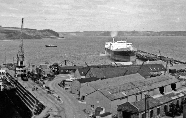
The depth of Carrick Roads has led it to being a place to layup large vessels awaiting sale or disposal. These included following World War II, numerous Royal Navy battleships, aircraft carriers and cruisers and in more recent times liners, tankers and other commercial vessel types.
")


The communities that grew up around Carrick Roads and the River Fal vary in size and importance. Truro grew up around the head of the Truro river at the confluence of the smaller rivers Kenwyn, Allen and the larger Truro River a tributary of the Fal. Much diminished due to silting up, the Truro River was once a major factor in the growth of Truro before Falmouth became dominant in maritime related industries. The Truro River passes Newham, an important 13th century port that helped establish Truro as a stannary town. It had facilities for exporting tin and copper as well as importing timber, coal and other goods. A railway station was established in 1855 allowing goods to be more easily transported to and from Newham, this closed in 1955. Newham is today home to over 130 businesses a key part of Truro’s commerce.
Malpas evolved from a river crossing. From just two houses in 1674 it now stretches from the confluence of the Truro and Tresillian Rivers along the shores of the latter. During the 18th century boatyards and other industries sprang up constructing vessels of up to around 120 tons. The popular Malpas Regatta was even attended by Queen Victoria and Prince Albert in 1846 aboard the royal yacht. Now part of the ‘Port of Truro’ many pleasure vessels are moored here today. Tresillian at the head of the Tresillian River, is an ancient manorial settlement mentioned in the 1086 Domesday Book of William I. First mentioned as ‘Tresulien’ in 1201 the hamlet grew as a crossing point where the river becomes non-tidal. By the 19th century river trade had expanding the settlement substantially. The road between Truro and St Austell over the historic bridge crossing was a driving force during the 20th century as silting diminished river trade. The village of St Clement, originally Moresk, with its castle in Norman times was a historic manor of the Earls of Cornwall. The parish it had its urban part incorporated into that of Truro in 1895. An attractive riverside village with its medieval church, sadly somewhat over restored, it has some genuine pre-14th century work remaining with the tower datestone showing 1326.


Further down the River Fal where it joins Carrick Roads is Restronguet Creek leading to the Rivers Kennall and Carnon along with various inlets. These over time would lead to various settlements based on contact with the Carrick Roads waterway. Perranarworthal has a 15th century church pointing to an early settlement, however it was the wharves along the River Kennall being built to facilitate tin smelting works that helped grow the settlement from the 18th century. As with other Cornish river settlements trade declined as the river silted up. Close by Devoran grew up as a tin and copper mining settlement with a small port for export and also the import of coal and timber. Close by there were 19th century wharves built at Point and Penpol. With its immediate access to Carrick Roads Feock grew up as a river crossing and as a maritime based settlement, its church dating from about 1264. With direct access to Carrick Roads the inhabitants occupations were involved with fishing, shipping and boatbuilding more akin to Cornish coastal communities, albeit within a sheltered waterway.
Further down within Carrick Roads is the village of Mylor that grew from a crossing point and bridge constructed in 1590. Some boatbuilding and a small dockyard to the mouth of the Mylor Creek led to the expansion of the settlement in the 19th century. Now of course it’s better known for yachting and home to the oyster fishing vessels. St Just in Roseland better known today for its beautiful church setting, grew on the edge of the St Just Creek and inlet. The current church built on the site of previous buildings was consecrated in 1216 and subsequently restored. Boatbuilding and other rural occupations were part of the communities occupational life.
During the 17th century the Trefusis family-built wharves at Flushing, where a settlement grew, due to its close ties with Falmouth and the Packet ships, aided by facilities including workshops and tradesmen based there. The name came from the Dutch wharf builders from Vlissingen known in 17th century English as Flushing.
Penryn one of the oldest towns in Cornwall retains much of its historic past in its buildings. First appearing in Domesday under the name Trelivel it became enfranchised and received its Charter in 1236. The important medieval Glasney College was built here in the 14th century, to extend the reach of the church. The 17th century trade in fish, tin and copper made it wealthy, but it later declined due to the growth of Falmouth. Falmouth was created around 1613 by Sir Peter Killigrew, following on from completion of Pendennis Castle in the 1540’s. It’s grown to become one of the largest towns in Cornwall. Falmouth’s location relating to shipping, close to the Western Approaches and amongst the busiest shipping lanes in the world, has aided this growth. Falmouth along with Penryn, its historic and close by neighbour, has too much history and heritage to share within this article.


Finally, St Mawes which was once a busy fishing port in historic times, within the wider waterway. It grew on the edge of the Percuil River that flows in the mouth of Carrick Roads. It’s now better known for its tourism and Tudor castle.
The shores of Carrick Roads and associated river systems created opportunities for settlements and industries utilising a collection of unique geographical features created millennia ago. Over the past thousand years this has been a boon to the wider Cornish economy and Cornwall’s inhabitants from prehistoric times.

